

In 1795, Florida was still a sparsely populated frontier under Spanish control with a mix of indigenous peoples, Spanish settlers, and formerly enslaved individuals. The Spanish had established several settlements and forts along the coast, including St. Augustine, which was the capital of Spanish Florida.
The area was characterized by a diverse cultural landscape, where Spanish, Native American, and African influences intertwined. The Spanish were engaged in conflicts with various indigenous groups, as well as the constant threat of British and American expansion from the north.
While settlements existed, the landscape was dominated by dense forests, swamps, and rivers, making travel challenging and communication slow. Daily life revolved around agriculture, trade, and the military presence of the Spanish garrisons. The economy was based on farming, with crops such as corn, beans, and tobacco being cultivated.
Spanish authorities sought to maintain control over the region as Britain and the United States eyed Florida as a strategic and valuable territory. After the American Revolution, Spain acquired East and West Florida from Great Britain; but the boundaries were not defined as Spain was claiming territory that was also claimed by Georgia, according to “Florida Against Georgia: A Story of the Boundary Dispute” published by Florida Historical Quarterly.

The recently established Treaty of San Lorenzo stated that boundaries be established by a commission of two, with each government selecting a representative. Andrew Ellicott, a surveyor, and engineer was selected by the U.S., while Captain Esteven Minor was chosen to represent Spain, according to the U.S. Office of the Historian.
The treaty implied that these commissioners, each having their own agenda, physically meet at the latitude line at 31 degrees, throw on their explore hats, and traipse through the wilderness together to determine the state line. What could possibly go wrong?
Ellicott and Minor initially started their journey on the east bank of the Mississippi River. Their route involved traveling down the Chattahoochee River until it met the Flint River, then heading east along the St. Marys River until reaching the Atlantic Ocean. However, their plans faced obstacles, and as a result, it took them four years to complete the survey.
Minor wasn’t exactly doing a river dance at the thought of traveling hundreds of miles with his adversary. According to the Florida Historical Quarterly, he was reluctant to make the trip and tried to foil progress with “many obstructive tactics”. His antics likely put a relationship with Ellicott on the rocks, or in this case, on the riverbed.
When the two reached the Chattahoochee River, another obstacle arose. Their travel plans of heading downstream to travel downriver to Flint, then jaunting east to the coast hit a big snag. The waterway was operated by Creek Indians who refused to let the survey progress. Since the Creeks technically had jurisdiction over the land, Ellicott and Minor avoided a watery standoff by procuring canoes and determining a new route for their aquatic adventure.
The change of plans included traveling downstream on the Chattahoochee River until they reached the Gulf. They then planned to travel around the coast of Florida to the mouth of St. Mary’s River, where they’d finish the survey by heading west.
The trip to the Gulf then down and around the coast of Florida was a long journey filled with many adventures and discoveries, most notably the commissioners’ encounter with William Augustus Bowles. Bowles was a British General who’d married and Creek Indian. The Spanish government loathed him because of his influence on the Native Americans. They eventually had him arrested and imprisoned at Morro Castle in Havana, Cuba. Spanish authorities were told he’d been hanged, but there he was in flesh and blood. Bowles told Ellicott the Cubans had banished him to the Philippines, but he’d escaped and made his way back to Florida. But that wasn’t the juiciest part of the discussion. Bowles intended to join the Creeks and lead a rebellion against both Spain and Britain – this tidbit of information was likely extremely valuable to both commissioners.
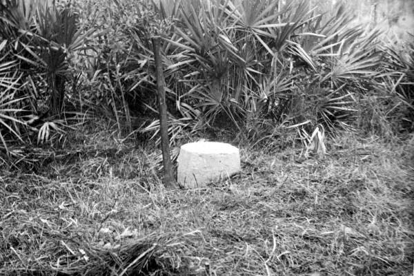
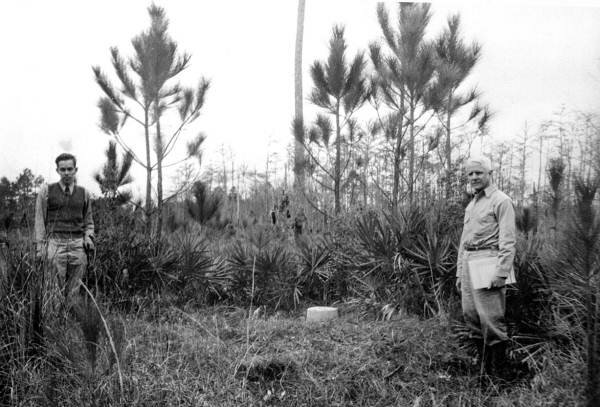
After completing their near circumnavigation around the state, the commissioners needed to establish a marker indicating the conclusion of their survey. Ellicott and Minor obtained canoes and navigated upstream to the Okefenokee Swamp. In this area, they identified various branches of the St. Marys River. After some deliberation, they reached a consensus on a specific point that would mark the end of their surveyed line. The marker needed to be discoverable as it was easy to get lost in the swamp, but not so distinct that the Native Americans might disturb. They ended up erecting a mound, that is now famously known as Ellicott's Mound.
At this point, the commissioners had already determined the latitude and longitude of the junction of the Chattahoochee and the Flint. Now, at Ellicott's Mound, they could conclude their journey by calculating the course of a line that ran between the two points without stepping foot on Native American land.
After their long journey, they retired to Castle William at Cumberland Island where General Nathaniel Green, a famed Revolutionary War hero, resided. Here they finished up their report, sending a letter of completion on March 22, 1800.
One might think that all that time spent together might bring the two commissioners together in friendship. Well, the letter stated otherwise. In it, Mr. Ellicott mentions some of the difficulties that confronted him during the progress of the survey. Among other things he says, "I am extremely anxious to have the report signed; for my want of faith is so great in all the officers of his Catholic Majesty that I suppose nothing was done till it is finished…this expedition has taught me a useful lesson: I was always pleased with our Government: I now think it perfect; I can now see the difference between a government whose basis is the people and one supported by intrigue, duplicity and parade: In the former man feels his dignity; he is open, candid and honest: But in the latter he becomes a jealous assassin.”
Find out the ensuing solution in next week’s edition of Sunday Favorites.


Comments
No comments on this item
Only paid subscribers can comment
Please log in to comment by clicking here.