
BRADENTON — Through the review of public records and HTML code from a redistricting website—davesredistricting.org—compelling circumstantial evidence has shown that some county commissioner concerns over how the redistricting process was being steered may not have been unwarranted. Information gathered by TBT raises questions as to whether commissioner-connected political operative, Anthony Pedicini, played a secretive role in drawing maps submitted in the county’s redistricting process.
The long and contentious redistricting process played out over several public meetings. There were assertions that the process had become mired in political motivation while some commissioners shared openly their suspicions that an outside entity was involved in the creation of Map B—a submission by Manatee County Commissioner Vanessa Baugh. Despite criticism of the process by both the public and some commissioners, the board was able to approve a finalized redistricting map created by Commissioner George Kruse in a 4-3 vote on December 14.
However, TBT has confirmed that the original Map B submitted by Commissioner Baugh on November 9—and subsequently edited and re-submitted by Baugh on November 13—was drawn by an account registered at davesredistricting.org by someone with a username of, "Anthony." Utilizing publicly accessible HTML inspect data, TBT painstakingly replayed past commission meetings comparing details in those to the "Anthony" account's map login activity stored as HTML.
In very basic terms, HTML is a computer language, a formatting system for displaying material retrieved over the internet. It scripts websites, instructing how the website will be displayed, everything from its colors to the layout of pages. Sometimes—such as in this case—when a website requires the user to create an account, the HTML also stores information like the username associated with the account and that user’s log-in activity. Any computer user can view a website’s HTML code by "right-clicking" with their mouse on a webpage and then selecting "Inspect" from the bottom of the drop-down menu.
To better interpret and understand how the HTML on davesredistricting.org was recording and displaying user data, I created my own account on the website using my TBT email address. Then, over the course of several days, I logged into my account and kept a journal of my logins, and what actions I performed.
I learned that the website assigns a username based on the prefix of the registrant’s email address. My TBT email is dawn.kitterman@thebradentontimes.com, so the website automatically assigned my username as "dawn.kitterman." This told me that whoever created the account where Commissioner Baugh’s Map B was drawn, did so with an email address that was "Anthony" followed by @whatever domain they use .com.
There are at least two email addresses published on the internet for Anthony Pedicini. The first—which is an older email address—is anthony@imagemgmt.com, and the other is anthony@simwins.com. "Simwins" refers to Pendicini’s political consulting firm, Strategic Image Management.
I also learned that—perhaps due to the location of the server that hosts the daveredistricting.org website—all login times saved in the HTML were five hours ahead of when the logins occurred locally. For example, I first created the map I titled, "Manatee Pretend" on January 8 at 10:09 p.m., but the HTML record showed January 9, at 3:09 a.m. You can view my login journal and HTML code here.
On a line labeled "modify time," HTML stored the last login where I had opened my map while I was signed in. Near the bottom, was a more detailed recording of my logins under "revisions" and "modify time." Each of these correlated with login sessions I performed in which I opened my saved map. If I simply signed in to the website but did not open my saved map, then there was no HTML record labeled "modify time" produced from the login session. HTML also appeared to only produce a login record from the moment I clicked my map, not from the moments I made changes or ended the session.
Having gained a basic understanding of how to read the HTML code generated by the website, I was able to review the "Anthony" map’s HTML against the timeline of events of maps submitted in the county’s redistricting process. Along with a "create time," there were a total of five HTML logins stored on the webpage of Baugh’s map: November 8, November 9, November 12, one on November 15, and a final login on November 22.
The Timeline
During a special meeting on November 9, Commissioner Vanessa Baugh submitted by email to John Guthrie—the redistricting consultant hired by the county—a link to a map created on the davesredistricting.org website. Baugh would state at the time—as well as repeatedly over the course of several meetings—that she had personally drawn the map.
In emails obtained by TBT dated November 9, Baugh first emailed the link to the map to herself at 7:53 a.m.—sent from her personal email, via her cell phone, to her county email—before then emailing that same link to County Administrator Scott Hopes at 9:09 a.m. This occurred nine minutes after the meeting had been called to order that morning.
In an additional email on the morning of November 9, Baugh forwarded the email she had previously sent to Hopes containing the link to her map at davesredistricting.org to the redistricting consultant at 9:26 a.m.—26 minutes after the special meeting had begun that morning.
Baugh—who was commission chair at the time—recessed the meeting for a ten-minute break at approximately 10:20 a.m. When the meeting reconvened, Baugh was absent. She returned after the vice-chair called the meeting back to order, with her cell phone in hand as she entered.
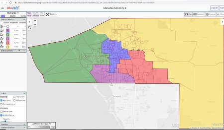
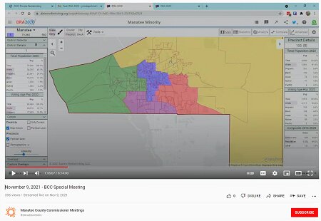
The link to Baugh’s map was an active link in mid-December when it first was obtained by TBT. When I copied and pasted the link into my browser's URL, it loaded a map on the davesredistricting.org website titled, "Manatee Minority B." The map that appeared contained mislabeled districts, just as Baugh’s map did during the November 9 special meeting. Not only were the county districts mislabeled, but they were also colored in the exact way that they appeared during the BOCC meeting on November 9.
When the consultant initially loaded Baugh’s map on the monitor that morning, Baugh—seemingly surprised—uttered aloud, "The numbers are wrong. Okay, I missed that part."
When the mislabeled districts confused a fellow commissioner who was trying to understand the map, she commented, "I was concentrating so hard on District 2 that I forgot to change the numbers."
When Baugh was questioned by Commissioners Whitmore and Servia as to the goal she had in mind when creating her map, and how it differed from the consultant’s map, she appeared unwilling—or unable—to provide specifics. She explained that because she had questions about District 2 and did not understand what the law required, following a conversation with the consultant, she decided she wanted to see what she could do with District 2 in keeping with the law.
While it seemed curious at the time that a commissioner would accidentally mislabel every district—including her own—Baugh attempted to explain the odd error away by stating she was extremely tired when she was working on the map and that she had, "worked on it all weekend." However, the HTML for the map associated with the link she emailed to Hopes and the redistricting consultant showed that username "Anthony" first created the map on November 8, at 6:13 p.m., the evening before the meeting. HTML recorded an additional "modify time" from November 8, at 7:12 p.m.
November 8 was a Monday. Not only was Baugh not working "all weekend" on the map associated with the "Anthony" account, but nobody was—not even "Anthony."
Another detail I noticed when I visited the link, was that the map’s name was no longer "Manatee Minority" as it appeared when first introduced by Baugh. The map’s name had been changed to "Manatee Minority B." I also noticed that the map’s district lines neither matched the map shown in the meeting video when it was first submitted, nor the revised version that came later and ultimately was the Map B made available to the public. This told me changes had been made to the map, even after Baugh’s Map B was published by the county.
There was also a login by "Anthony" stored in HTML from November 9, the morning of the meeting, at 11:29 a.m. This occurred a little less than 20 minutes after the special meeting had recessed for lunch at approximately 11:11 a.m.
After more than an hour’s worth of discussion in the morning about Baugh’s map, the consultant’s map—even the addition of another draft map proposed by Commissioner Servia—and then another hour of discussion after lunch recess, commissioners finally agreed to move forward with three maps they wanted consultant Guthrie to present to them at the next regular meeting: the consultant’s Map A, Baugh’s Map B, and Servia’s Map C.
The commissioners also agreed that any conversations with Guthrie prior to the next meeting should be reserved for questions only, not map changes. While it was anticipated that some "clean-up” of the newly introduced maps from Baugh and Servia may be needed, the unanimous opinion of the members was that no significant changes would be made in private to any map and that the most transparent way to make significant changes to a map would be in the public’s view.
On November 16, the commission convened for a regular meeting with the redistricting item scheduled time certain for 2 p.m. However, it was clear shortly after the meeting was called to order that something had transpired concerning the maps.
Commissioner Servia expressed confusion as to why all the proposed maps were not available for review prior to the night before the meeting. The consultant had informed her that there were some changes to Baugh’s map that delayed his ability to return the maps to the county in time to be included in the agenda sooner.
When the 2 p.m. time-certain arrived, Servia began the discussion where she left off from her morning’s comments, "My understanding was that we had agreed last meeting that no changes were to be made to any of the maps." She sought clarity from the consultant, asking him to confirm whether her fellow commissioners held to that agreement.
Mr. Guthrie retold how he received an email from Baugh on November 13 which contained a new "cleaned up" version of the map she had previously submitted. Baugh had taken it upon herself to "clean up" her Map B, and it was her revised version that was attached to the meeting’s agenda.
Commissioner Servia questioned Baugh, "These maps are yours and no one else?"
"Only mine and no one else," Baugh snipped. "They do have my name on them." Baugh continued, "Commissioner Servia, I really don’t appreciate your line of questions. I will tell you that I sat down, as I did in the meeting the other day, to try to come up with the best map that I could for the minority district of District 2."
The meeting concluded with the board advancing the consultant’s Map A and Baugh’s Map B further in the redistricting process while removing Servia’s Map C from any further consideration. The vote was 4-3 with Commissioner Kruse, Baugh, Van Ostenbridge, and Satcher voting "for" and Servia, Whitmore, and Bellamy casting "nays."
TBT submitted a record request on Monday, January 10, 2022, for a copy of the November 13 email from Baugh to the consultant. That email showed that Commissioner Baugh emailed the consultant at 3:34 p.m. on November 13. Included in the records request were copies of any emails between specific commissioners—including Vanessa Baugh—and Anthony Pedicini, those emails were targeted to relevant dates within the timeline.
Three days later, I received a partial response to my request. There existed no records of emailed correspondence through county email accounts with Anthony Pedicini and any of the commissioners I specified. However, the copy the county provided of the November 13 email from Baugh to the consultant contained intriguing clues.
The first thing the email confirmed is that the link Baugh sent the consultant to access her "cleaned up" revision of Map B, was the very same link that appeared in the email she sent to herself, then to Hopes, and then forwarded to the consultant on the morning of the November 9 meeting. When a user makes changes to a map they have created on davesredistricting.org, the updates display at the same link as when the map was first created. The email Baugh wrote included, "Here are adjustments made to my minority map."
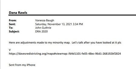
Interestingly, the next login recorded in HTML from username "Anthony" was dated November 12, 1:07 p.m., the afternoon before Baugh sent the davesredistricting.org link to the consultant the second time.
Also interesting, within approximately 48 hours of submitting the request for records as detailed above, the link to the map became inactive. That is to say, the link that provided me access to Baugh’s map and that I had been able to access for research beginning in mid-December, had been deleted.
Sometime between Tuesday morning January 11, and Wednesday afternoon January 12, someone deleted the "Manatee Minority B" map from the davesredistricting.org website.
I had already taken detailed screenshots to preserve continued access to the HTML for my work, as I suspected there was a chance the map would be removed.
The next login recorded in HTML was dated November 15 at 11:26 p.m., the night before the November 16 regular meeting with a 2 p.m. redistricting time certain.
It would be about two weeks before the topic of redistricting would again be addressed in a commission meeting. During that time, the county displayed the selected maps in public libraries and on its website for public review. TBT also published an article titled, A by the Numbers Look at the BOCC Draft Redistricting Maps, in which I analyzed the data charts provided on both maps. (If you missed that reporting, you may want to scan some of what I was able to parse out concerning minority VAP of District 2, as well as the questionable—if not nonsensical—deviations of district populations).
Also, during those two weeks, Commissioner Servia—the only commissioner to do so by that point—hosted three town halls on redistricting in which she displayed enlarged prints of the draft maps for public inspection and to hear community feedback.
On December 2, in a land-use meeting, the topic of redistricting again took center stage. The topic was not originally scheduled to be addressed in the meeting, and based on commissioner comments, members were caught off guard by the addition of a 9:00 a.m. time certain that included, "Compromise of redistricting map for consideration" and "School Board Redistricting Map," to the meeting’s agenda the evening before. It was in that land use meeting that the board approved replacing Commissioner Baugh's Map B with the late addition "compromise map" submitted by Commissioner George Kruse.
Kruse explained to the board that it was the division of the urban core by Baugh’s Map B that was the foundation of his "compromise map."
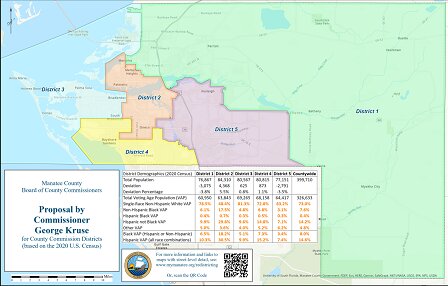
"This is a map B with adjustments," Kruse said, citing the importance of looking toward the future of Manatee County. Kruse added, "The thing that really caught my eye about Map B—was that downtown Bradenton was carved out for District 3."
At no other time in previous discussion or debate over Map B—not even in my own reporting where I analyzed the data charts—had anyone pointed out or raised objection to the fact that Baugh’s map placed downtown Bradenton into District 3, splitting the urban core. But when Kruse explained in the December 2 meeting that he sought to divide the urban core, it raised the eyebrows of at least three fellow commissioners. Whitmore said she strongly objected to any map dividing the cities of Palmetto and Bradenton into two separate districts.
Upon revisiting the maps, it is easy to see—when you know what you are looking for—that yes, the original and revised version of Baugh’s Map B did carve out downtown Bradenton, removing it from District 2 and placing it into District 3. It can be seen in the November 9 meeting when she first submitted her map "Manatee Minority."
It can be seen again in the revised version that replaced her previous Map B at the November 16 meeting, in which Baugh allegedly revised the map herself. Despite both versions of Map B submitted by Baugh carving out downtown Bradenton into District 3—and presumably because of the nature in which maps were being submitted last minute and without time for closer inspection or street details—the fact that her map removed downtown Bradenton went unnoticed by some on the board.
Based on comments made by Commissioners Servia, Bellamy, and Whitmore, it was clear that had they been aware that earlier maps had placed downtown Bradenton into District 3, they would have spoken strongly in opposition to said maps.
But not all commissioners took issue with Kruse’s compromise map. District 3 Commissioner Kevin Van Ostenbridge stated that while he wasn’t thrilled about the process—he "loved" the idea that Kruse’s map brought some of downtown Bradenton into District 3.
Commissioner Baugh remarked, "I do like this better… if there is a motion made, I will support this map."
Baugh also chastised Commissioner Servia for being critical of the process and lack of transparency. "I’ve heard the word ‘trickery’ from you Commissioner Servia, and I take true exception to that. There has not been any trickery regarding these maps, at least not by me," said Baugh.
"I appreciate the fact that Commissioner Kruse took the time to look at the map I drew, and to improve it, which I think he did," she continued, "You’re the ones doing the politicking up here, the rest of us are trying to be open and honest."
Acknowledging the criticism that some commissioners laid upon him, Kruse offered that his having created the map was something specifically requested of him the Wednesday before the meeting by County Administrator Scott Hopes—that Wednesday was November 24.
However, emails obtained by TBT show that Kruse emailed Hopes on November 22 at 7:44 p.m. and asked, "Did you get me access to the 'official' map software?"
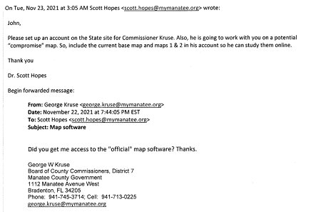
Hopes forwarded Kruse’s email to Guthrie on the morning of November 23 at 3:05 a.m., writing, "John, please set up an account on the State site for Commissioner Kruse. Also, he is going to work with you on a potential ‘compromise’ map. So, include the current base map and maps 1 & 2 in his account so he can study them online. Thank you."
Once again, as with the previous instances when new unanticipated maps were created and submitted, HTML code associated with Baugh’s map from davesredistricting.org registered to someone with a username of "Anthony," showed a "modify" login on November 22, 11:49 a.m. That would be the fifth and final login recorded in HTML to the link associated with Baugh’s Map B.
TBT included in the record request submitted Monday, January 10 all emails between Administrator Hopes and Commissioner Kruse related to the county's redistricting process, targeting a specific date range. At the time of publication, that portion of our request had not been satisfied.
Anthony Pedicini
While it is true that the owner of the davesredistricting.org account that produced Baugh’s maps—and who was the first to propose removal of downtown Bradenton from district 2—had a username of "Anthony," a first name alone is not "proof." There is only one "Anthony," however, that has publicly known connections to four of Manatee County’s current commissioners.
Pedicini is a political operative whose Tampa-based firm assists Republican candidates to win elections. Historically, part of his firm’s political "strategy" has included large amounts of money to produce negative campaign mailers against his clients' political opponents via PACS. According to reporting in the Bradenton Herald, campaign finance records of Commissioners Baugh, Kruse, Van Ostenbridge, and Satcher show Pedicini’s firm served as a political consultant to their 2020 election campaigns.
If you recognize Pedicini's name, however, it's likely not because of his work behind the shady political curtain, but because it was central in a tense March 23, 2021, regular meeting.
As reported by the Bradenton Herald, Commissioner Servia raised concerns about Mr. Pedicini having inserted himself into county business during a commission trip to Tallahassee. Pedicini is not a resident of Manatee nor employed by the county, but according to Servia, Pedicini inappropriately organized and even attended county legislative meetings at the state capitol with Manatee County Commissioners Kruse, Baugh, and Van Ostenbridge.
While Kruse, Baugh, and Van Ostenbridge defended Pedicini’s participation in efforts to advance the county’s agenda, Servia said it was improper to invite an outsider to arrange meetings with state legislators and to attend some of those. Furthermore, Servia asserted that giving a political "hack" whose firm represents politicians from other counties a front seat to Manatee County’s negotiations and inside discussions, could put Manatee at a disadvantage.
A less widely known fact about Pedicini—and more relevant to this reporting—is his prior experience with redistricting. His name appeared among thousands of emails released in connection with the state redistricting scandal of 2011.
As reported in the Orlando Sentinel in November of 2014, the Florida Supreme Court ordered the release of emails from GOP political operatives who participated in a plot intended to circumvent Florida’s constitutional ban on gerrymandering. The suit alleged political consultants were secretly drawing and submitting public maps through third parties.
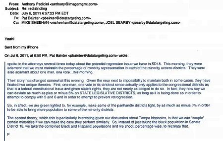
Pat Bainter, the president of the GOP political consulting firm Data Targeting, was at the center of the scandal. When the thousands of emails were released, among them appeared correspondence with Bainter and Anthony Pedicini. In one such email, Pedicini wrote to Bainter telling him he had created an alternative map called "Impartial" that constructed a Central Florida Hispanic congressional seat to draw three Tampa Republicans into the same district.
In another email, Bainter wrote to Pedicini on the subject of "retrogression" and standards required to comply with Amendments 5 and 6 of the Voting Rights Act. Legislators must decide how many new districts should be carved to elect minorities, and "retrogression" refers to a reduction in the voting strength of a racial or ethnic minority based on a redistricting plan. One potential angle referred to in the email is the "coupling" of different groups of minority voters to create a total minority VAP within a legally defensible deviation of current benchmarks. Pedicini responds to Bainter with one word, "Yeah!"
The League of Women Voters of Florida and other groups brought legal challenges to the state’s redistricting maps of 2011, and subsequently, the court ruled maps were to be redrawn. Visit the 2015 reporting from the Tampa Bay Times for more details.
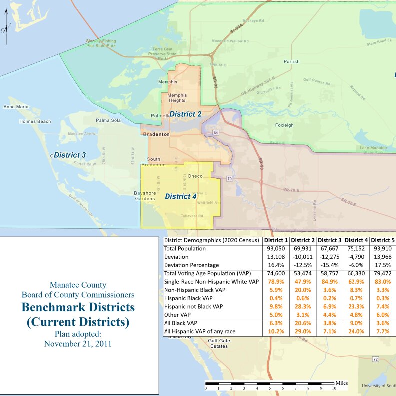
Total minority VAP, as well as Hispanic and Black VAP, within District 2 came up several times and in more than one of Manatee County’s meetings on redistricting. Discussion about the Voting Rights Act and what constitutes "legally defensible"—particularly in terms of population deviation of minority VAP in District 2—was especially present in the commission’s December 7 special meeting on redistricting.
Based on the data deviations, the map adopted by the commission to redistrict Manatee County has been said to be legally defensible by outside counsel, as well as in the non-legal opinion of redistricting consultant John Guthrie. If a political operative—who has made their living representing GOP candidates in elections—may have been secretly submitting maps to a county’s redistricting process—whether that would pose legal issues for any such map, may require determination by the courts.
TBT reached out to Commissioner Vanessa Baugh via email and received no reply to our request for comment. Anthony Pedicini declined to comment on this story as well, claiming he'd been misquoted in a previous story and that he would require a personal apology from the publisher before doing so.
Dawn Kitterman is a staff reporter for The Bradenton Times. She covers local government and entertainment news. She can be reached at dawn.kitterman@thebradentontimes.com.


Comments
No comments on this item
Only paid subscribers can comment
Please log in to comment by clicking here.