
As of Tuesday morning, a low-pressure system, Potential Tropical Cyclone Nine, has the potential to turn into a catastrophic hurricane by Thursday. Tropical Storm Helene formed in the Caribbean Tuesday morning. This system will not be like a typical hurricane, where we have had days of a storm moving in our direction and the accompanying media attention. This storm is predicted to go from a low-pressure area with the current 30-mile-per-hour winds to over 100 miles per hour within the next two days.
We are at the edge of the east side of the cone, the same as Ft. Myers when they were devastated. Models the forecasters use are based on historical trends and are not an exact science. The trend with a number of Hurricanes, for some reason, has been a shift east. We don’t know if this will turn more east like several others that did not follow the path the models predicted, but since we are in the cone, we need to plan for a possible direct hit of a possible Category 3 or 4.

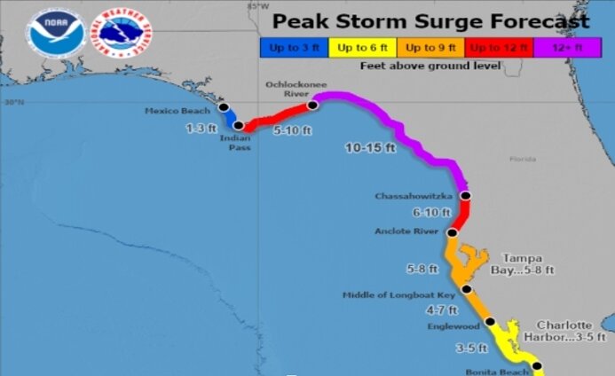
Storm surge is already forecast to be as high, if not more, than the previous storms. At Anclote River, FL to Middle of Longboat Key, FL...5-8 ft, Tampa Bay...5-8 ft, Middle of Longboat Key, FL to Englewood, FL...4-7 ft, Englewood, FL to Bonita Beach, FL...3-5 ft, Charlotte Harbor...3-5 ft and it could be more severe than the current forecast. It also depends on whether the peak surge is at high tide.
A Hurricane Watch has been issued for the Gulf Coast of Florida from Englewood northward and westward to Indian Pass, including Tampa Bay. What this should trigger is executing your hurricane plan. The storm is predicted to track north. Anyone in a Coastal Barrier Island and older Mobile Homes should consider evacuating before Thursday.
Flooding is the primary cause of death from these storms. If you shelter in place, ensure you have water and medicines for at least seven days; it is best to have a two-week supply. You should fill your bathtub with water just in case the water system fails. Make sure you have a flashlight with extra batteries. Your go-to room during the worst winds should be a room without windows, like a bathroom or even a closet. Have games for the kids to play.
The Red Cross has an excellent site on Hurricane Preparation at this link. Manatee County has a webpage that has several links to resources from weather to shelters at this link.
Please take this storm seriously and prepare as if we were going to have a direct hit. We are in the cone and on the east side of the storm, where the weather will be the most extreme. They call it the dirty side of the Hurricane because it is where the highest winds, storm surges, rain, and tornado threats will occur. The impacts will arrive by early Thursday morning. Be safe!


Comments
No comments on this item
Only paid subscribers can comment
Please log in to comment by clicking here.