
As I write this on Monday morning, like many of you, I am in a bit of a shock. Hurricane Milton is forecast to strike the Gulf Coast around where we live on Wednesday. This is less than two weeks after Hurricane Helene hit the Gulf Coast to our North. From Hurricane Helene, my island property had two feet of water but was spared the destruction so many properties had faced. We would have had all the repairs done this week, but Mother Nature had other plans.
Today is prep day, and maybe you will have some time on Tuesday. The storm surge forecast for this storm is already higher than Helene's by almost 4 feet. The cause of the surge is a combination of the hurricane's low pressure and winds, together with the tide at that peak, which determines the height of the water levels. There is an increasing risk for life-threatening storm surges and wind impacts beginning late Tuesday into Wednesday.
One of the many surge products I wanted to share has more specifics as to the timing and height of the water level. The PROBABILISTIC TROPICAL STORM SURGE website is called experimental, but I find the official NHC data lacking specifics. The height of the water level is the surge and tide level added together. I have a high level of confidence in this product since it had the water levels for Hurricane Helene forecast and the actual water levels matching, as you can see in the forecast as of today. Coordinated Universal Time(UTC) is 4 hours ahead of us. Sometime around midnight Wednesday/Early Thursday morning, water levels will peak, but the rising water will take place before sunset. We reach Helene water levels around 8 PM. If this holds, expect water levels to exceed Helene for around six hours.

Hurricanes rotate counterclockwise, circular from right to left. This drives the surge along with the low pressure, which is like a suction pulling the water up. This is why the highest water heights will occur along the immediate coast near and to the south of the landfall location, where large and dangerous waves will accompany the surge. Surge-related flooding depends on the relative timing of the surge and the tidal cycle and can vary significantly over short distances.
The National Hurricane Center(NHC) is the recommended website, but other sites like this help provide some great information to understand impacts along with local TV news stations. Here is the latest updated 600 AM CDT Mon Oct 07 2024...NOAA HURRICANE HUNTERS FIND MILTON A MAJOR HURRICANE...
“Data from a NOAA Hurricane Hunter aircraft indicate that Milton has strengthened to a major hurricane. The maximum sustained winds are estimated to be 120 mph (195 km/h). Milton is a category three hurricane on the Saffir-Simpson Hurricane Wind Scale. Data from the aircraft also indicate that the minimum pressure has fallen to 954 mb (28.17 inches).”
Other websites include Mike's Weather Page. On it, you will have more links to lots of data. Mike also provides an update with a video. If you want to explore the models that provide some guidance on where these storms go, Tropical Tidbits is a great site. Scientists use models to forecast weather. A variety of models are specific to Hurricanes.
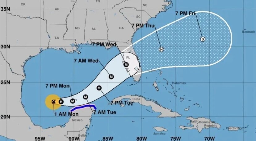
Below is the latest image from the GFS model, our worst-case scenario: a hurricane hitting north of Tampa Bay. In Tropical Tidbits, you get to click on the Hurricane Model that is specific to the Hurricane you select. Then, you can look at each forecast hour increment. What you will find is a spread of what is predicted. Some have it with this storm hitting us, some north, some south. The NHC will use these models and their experience to advise the public.

Don’t focus on any one model, but this is the science if you want to explore more information. These models are run several times a day based on the Hurricane Hunters that fly the storm and pick up critical data. The models need this data from the planes flying in and out of the storm to provide the best data to run an accurate model. Models also use historical weather to produce as accurate a forecast as possible. The track forecast for Helene was pretty good, but it did, in the end, go a bit more East than the forecast, missing Tallahassee with the direct hit that was forecast. REMEMBER, HURRICANES ARE NOT ONE HUNDRED PERCENT PREDICTABLE. A last-minute wobble or unexpected turn may happen, so be prepared.
Hurricane Milton will be the most powerful hurricane to hit our area since we have developed into a dense coastal community. You will hear in the forecast that Milton will become a category 5 and then will reduce intensity before landfall. However, it is forecast to be a Category 3 with devastation still we have never seen in this area. I fly for the Coast Guard Auxiliary and, on Saturday, observed firsthand the destruction from Hurricane Helene north of Cedar Key. This destruction was in a sparsely populated area of Florida in the middle of mangrove shorelines. Hurricane Milton will be just as powerful, and any frame structure as with Helene at ground level was wiped away into a pile of rubble.
Anyone on any of our islands and living in coastal communities like Cortez that are below 11 feet must get off the island by Wednesday. As a Republican County Commissioner for 22 years, I was proud to have a state government that focused on planning for disasters like this and insisted communities prepare for hurricanes. Not to get political, but the reason we are not better prepared is that Governor Scott, now a Senator, decided to eliminate the Department of Community Affairs and replace it with the Development of Economic Opportunities because developers like Carlos Beruff and our State Senators like Bill Galvano wanted less so-called bureaucracy.
What this really meant was that they chose to allow a developer's profits to be a higher priority than the safety of our citizens. We had really good bipartisan planning, ensuring adequate roads were required, and yes we had hurricane plans. Instead, this year, Governor DeSantis signed a bill that deletes most of the mentions of climate change from state law. He did this even as most of South Florida faced record-high temperatures that fuel hurricanes.
Here is a snippet from Craig Pitman’s article featuring the steady voice of a reporter calling it like it is.
“When he signed the bill, DeSantis boasted in a post on X (formerly Twitter), “We’re restoring sanity in our approach to energy and rejecting the agenda of the radical green zealots.” I bet his office sound system was blaring Bruce Springsteen’s “Pink Cadillac” or Prince’s “Little Red Corvette” while he added his addled John Hancock.
Sanity? What sanity? Folks, the “radical green zealots” who put that language in the law in the late 2000s were his fellow Republicans. They weren’t wearing tie-dyed shirts and sandals. They had on blue blazers, rep ties, and tassel loafers.
They could see that rising seas and temperatures were becoming a serious threat. That’s why they wrote laws that said the state would set up policies for dealing with it. They set goals to cut the use of fossil fuels in Florida and encourage clean alternatives like solar.”
Please take every precaution within reason, and don’t take this storm like we have been through this before. Make sure you have your preparation done as much as you can today, and ensure you have a safe room to hide from the wind. Please do not stay in a home that is below 11 feet in elevation. Remember how Helene impacted us so much when it was so far away? This will be much closer if not directly hitting us. WE ARE IN THE CONE, WHICH YOU SHOULD CONSIDER IT HITTING US DIRECTLY. Let’s hope this is not our storm, but if it is, we should be prepared for the worst.


1 comment on this item
Only paid subscribers can comment
Please log in to comment by clicking here.
Libby23
Thank you so much for this useful information. Wishing you and all Manatee County residents a safe landing.
4 hours ago Report this